Shandong launched four-level emergency response for flood control and typhoon prevention.
CCTV News:According to "Shandong emergency managementAccording to WeChat official account news, the Shandong Meteorological Observatory issued the No.5 typhoon "Du Surui" forecast and the yellow rainstorm warning at 10: 30 on July 28th. This year’s No.5 typhoon "Du Surui" landed in the coastal area of Jinjiang City, Fujian Province around 9: 55 on July 28th. When landing, the maximum wind force near the center was 15 (50 m/s, strong typhoon level), and the lowest pressure in the center was 945 hectopascals.
It is estimated that Du Surui will move to the north-west direction at a speed of 25 kilometers per hour, and its intensity will weaken rapidly. On the 29th, it will weaken into a tropical depression (magnitude 6-7), and on the 30th, it will continue northward through the western part of Shandong Province (Figure 1).
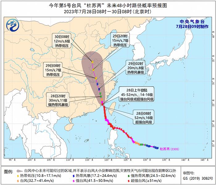
Fig. 1 Forecast chart of the moving path of Typhoon Du Surui No.5.
Start the four-level emergency response for flood control and typhoon prevention.
According to the Emergency Plan for Flood Control and Drought Relief in Shandong Province, after comprehensive consultation and judgment, the provincial defense index decided to start the four-level emergency response for flood control and typhoon prevention at 12 o’clock on July 28.
All kinds of flood control responsible persons at all levels should immediately take up their posts and do a good job in typhoon and heavy rainfall prevention and response. All relevant units at all levels should promptly implement various preventive measures according to the division of responsibilities. All relevant cities and counties in the typhoon-affected area should pay close attention to the typhoon trend, roll monitoring and analysis, encrypt consultation and judgment, issue early warning in time, start response, strictly implement the emergency "call-and-answer" mechanism, give priority to personnel transfer and avoidance, pay special attention to the prevention of geological disasters such as mountain torrents, water conservancy project dispatching and patrol defense, urban and rural waterlogging prevention and road traffic control, report dangerous situations and disasters at the first time, and make solid preparations for emergency rescue to ensure the safety of people’s lives and property.
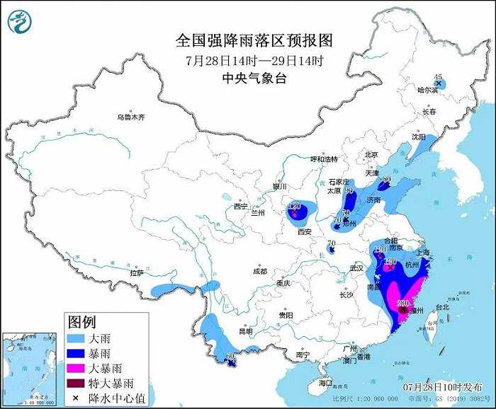
The influence of Du Surui on Shandong Province is mainly rainfall. It is estimated that there will be heavy precipitation in the western and central parts of Shandong Province from the night of 28th to the day of 31st. The cumulative average precipitation in the whole province is 80-110mm (Figure 2), in which Heze, Jining, Zaozhuang, Linyi, Rizhao, Jinan, Tai ‘an, Zibo, western Weifang, Liaocheng, Dezhou, Dongying and Binzhou are 100-150mm, and 250mm or more in other areas. The maximum hourly precipitation is 60 ~ 80mm. At the same time, the wind gradually increases from south to north, with 7 gusts in the southeast wind, the central Yellow Sea and Bohai Sea, and 8 gusts in the Bohai Strait, the northern Yellow Sea and inland areas. The specific rainfall forecast is as follows:
From the night of 28th to the day of 29th, there were heavy rains and local heavy rains in Heze, Jining, Zaozhuang, Linyi, Rizhao, Jinan, Tai ‘an, Zibo, Weifang, Dezhou, Liaocheng, Binzhou and Dongying, and moderate rains and local heavy rains in other areas.
From the night of 29th to the day of 30th, there were heavy rains in Heze, Jining, Zaozhuang, Linyi, Rizhao, Jinan, Tai ‘an, Zibo, Weifang, Dezhou, Liaocheng, Binzhou and Dongying, with heavy rains in some areas and small to moderate rains in other areas.
From the night of the 30th to the day of the 31st, Liaocheng, Dezhou, Binzhou and Dongying experienced heavy rains, while other areas experienced small to moderate rains.
On the evening of July 27th, the Office of Shandong Flood Control and Drought Relief Headquarters issued the Notice on Doing a Good Job in the Defense of Typhoon Du Surui No.5 this year, requiring all levels and departments to fully estimate the most serious impact that this typhoon may cause, to tighten the responsibility for flood control and typhoon prevention, and to do a good job in various defense measures.
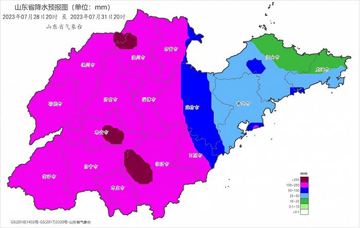
Figure 2 Precipitation forecast chart from 20: 00 on July 28th to 20: 00 on July 31st, 2023 (unit: mm)
Typhoon Du Surui landed on the coast of Jinjiang, Fujian at 9: 55 today. When it landed, the maximum wind force near the center was 15 (50 m/s, strong typhoon level). It is expected that Du Surui will continue to move to the northwest after landing, and its intensity will gradually weaken.
The Central Meteorological Observatory continued to issue a typhoon red warning at 06: 00 on July 28, and continued to issue a rainstorm orange warning at 10: 00.